Vingåker station - Saturday schedule
| Line | Direction | Time |
|---|---|---|
| 730 | Katrineholm Centralstation | 07:10 |
| 152 | Stockholm Centralstation | 08:10 |
| 405 | Katrineholm Centralstation | 08:32 |
| 730 | Vingåker Station | 08:50 |
| 402 | Högsjö Bruk | 08:52 |
| 730 | Katrineholm Centralstation | 09:10 |
| 123 | Hallsberg Station | 09:14 |
| 126 | Stockholm Centralstation | 09:39 |
| 402 | Vingåker Station | 10:08 |
| 730 | Katrineholm Centralstation | 10:10 |
| 730 | Vingåker Vannalaplan | 10:20 |
| 125 | Hallsberg Station | 10:20 |
| 128 | Stockholm Centralstation | 10:42 |
| 730 | Vingåker Vannalaplan | 10:49 |
| 730 | Katrineholm Centralstation | 11:10 |
| 127 | Vingåker Station | 11:17 |
| 405 | Vingåker Station | 11:31 |
| 130 | Stockholm Centralstation | 11:40 |
| 730 | Vingåker Station | 11:50 |
| 402 | Högsjö Bruk | 11:52 |
| 730 | Vingåker Vannalaplan | 12:49 |
| 131 | Hallsberg Station | 12:58 |
| 402 | Vingåker Station | 13:08 |
| 730 | Katrineholm Centralstation | 13:10 |
| 134 | Stockholm Centralstation | 13:42 |
Directions to Vingåker with public transportation
The following transit lines have routes that pass near Vingåker
How to get to Vingåker by train?
Click on the train route to see step by step directions with maps, line arrival times and updated time schedules.
Train stations near Vingåker
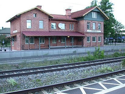
- Vingåker Station, 3 min walk,
Bus stops near Vingåker
- Lärkparksvägen, 3 min walk,
- Vingåker Norra Torggatan, 5 min walk,
- Vingåker Slottet, 10 min walk,
Bus lines to Vingåker
- 401, Byle,
- 402, Sävstaskolans Vändslinga,
- 672, Slottsskolan,
- 730, Vingåker Station,
- 405, Katrineholm Centralstation,
- 676, Vingåker Station,
- 674, Marmorbyns Skola,
What are the closest stations to Vingåker?
The closest stations to Vingåker are:
- Vingåker Station is 163 meters away, 3 min walk.
- Lärkparksvägen is 230 meters away, 3 min walk.
- Vingåker Norra Torggatan is 382 meters away, 5 min walk.
- Vingåker Slottet is 774 meters away, 10 min walk.
Which bus line stops near Vingåker?
730
Which train lines stop near Vingåker?
These train lines stop near Vingåker: 125, 129.
What’s the nearest train station to Vingåker?
The nearest train station to Vingåker is Vingåker Station. It’s a 3 min walk away.
What’s the nearest bus stop to Vingåker?
The nearest bus stop to Vingåker is Lärkparksvägen. It’s a 3 min walk away.
What time is the first train to Vingåker?
The 118 is the first train that goes to Vingåker. It stops nearby at 5:42 AM.
What time is the last train to Vingåker?
The 151 is the last train that goes to Vingåker. It stops nearby at 11:17 PM.
What time is the first bus to Vingåker?
The 730 is the first bus that goes to Vingåker. It stops nearby at 5:05 AM.
What time is the last bus to Vingåker?
The 730 is the last bus that goes to Vingåker. It stops nearby at 10:51 PM.
See Vingåker on the map
Public transit to Vingåker station
Looking for directions to Vingåker in Vingåker, Sweden?
Download the Moovit App to find the current schedule and step-by-step directions for Train, Bus or Metro routes that pass through Vingåker.
Looking for the nearest stops closest to Vingåker ? Check out this list of closest stops to your destination: Vingåker Station; Lärkparksvägen; Vingåker Norra Torggatan; Vingåker Slottet.
Bus: 730, 401, 402, 672, 405, 676, 674, 674.Train: 125, 129, 117, 118, 119, 120, 121.
We make riding on public transit to Vingåker easy, which is why over 1.5 million users, including users in Vingåker trust Moovit as the best app for public transit.
Use the app to navigate to popular places including to the airport, hospital, stadium, grocery store, mall, coffee shop, school, college, and university.
The station has the following entrances: Järnvägsgatan and Sävstaholmsvägen
The first line to this station is 730, at 07:10, and the last line is 730 at 00:55.
This station serves Mälartåg and Sörmlandstrafiken’s lines
Popular routes from Vingåker
Train station near Vingåker
Vingåker StationPopular public transit stations in Vingåker
Gävle Centralstation,Stockholm Södra Station,Jungfrugatan,Råcksta Begravningsplats,Kyrkvägen,Östertälje Station,Gnesta Station,Uppsala Viktoria,Odenplan,Skanssundet,Ursvik,Uppsala Akademiska Ing 78-85,Hertig Carls Väg,Dalens Sjukhus,Jakobsberg,Uppsala Molngatan,Västertorp,Siggebogården,Ekuddsvägen,Mall Of ScandinaviaGet around Stockholm by public transit!
Traveling around Stockholm has never been so easy. See step by step directions as you travel to any attraction, street or major public transit station. View bus and train schedules, arrival times, service alerts and detailed routes on a map, so you know exactly how to get to anywhere in Stockholm.
When traveling to any destination around Stockholm use Moovit's Live Directions with Get Off Notifications to know exactly where and how far to walk, how long to wait for your line, and how many stops are left. Moovit will alert you when it's time to get off — no need to constantly re-check whether yours is the next stop.
Wondering how to use public transit in Stockholm or how to pay for public transit in Stockholm? Moovit public transit app can help you navigate your way with public transit easily, and at minimum cost. It includes public transit fees, ticket prices, and costs. Looking for a map of Stockholm public transit lines? Moovit public transit app shows all public transit maps in Stockholm with all Bus, Train, Metro, Light Rail, Ferry and Cable Car routes and stops on an interactive map.
Stockholm has 6 transit type(s), including: Bus, Train, Metro, Light Rail, Ferry and Cable Car, operated by several transit agencies, including SL Tunnelbana, SL Spårvagn, SL Lokalbana, SL Rail, UL, Flygbussarna, Sörmlandstrafiken, X-trafik, Region Gotland, VL, Trosabussen, Vy Bus4You, Bergkvarabuss, Silverlinjen, Y-buss